The CENTENNIA Historical Atlas

A dynamic, animated guide to a thousand years of history...

Centennia Research Edition ($)

Centennia Research Edition, or CRE, has been designed for professional academic research and analysis by historians, political scientists, and economists requiring basemap data for political entities in Europe and the Middle East during the past ten centuries. The maps may be imported into any modern GIS analysis system.

Centennia Research Edition is being used in current academic research in econometric history. Here's a preview of an upcoming article: Creative Destruction in the European State System : 1000-1850 by David Schönholzer, Eric Weese.

The database in CRE is a strategic asset of Clockwork Mapping constituting a storehouse of intellectual property for our Centennia Historical Atlas commercial products, both now and in the future. Because of this critical value to us, and since the data is rare and valuable to research, we price CRE at a high level as a professional tool, and we further require signed contracts guaranteeing controlled access to and protection of the data.

Licenses for Centennia Research Edition start at $12,500 for the database, as is. We provide samples for analysis prior to licensing but full access is granted only upon payment and delivery of signed licensing contracts. If any modification of the database is required, or if any additional features are required, licensing fees may be higher.

SOME FEATURES OF CRE:

  • Complete internal database of all Centennia Historical Atlas entities.
  • 4.5 gigabytes of data (zip compressed), 18G uncompressed.
  • Standard KML data format, compatible with all modern GIS.
  • Latitude/longitude rectified.
  • Polygons and identifiers at all dates.
  • Political polygons extend past coastlines.
  • Merge with any coastline overlay.
  • Complete KML coverage for every tenth of year.
Please contact us if you're interested in purchasing a license of CRE.

OTHER LICENSING OPTIONS:
All licenses of Centennia Research Edition (CRE) require a signed licensing contract and include limitations on publication, display, and other uses.

  • CRE Single-date: KML data for any single year. We can provide a complete map for any single date in the period from 1000AD-2003 for $75 with a signed contract. Maps in the period 1789-1939 may be displayed publicly or posted on the Internet at no additional cost (raster versions of maps only, no vector data of any sort). Contact us for details.
  • CRE 1789-1939: KML data covering 1789-1939 only. Since Centennia Nations Edition covering the period 1789-1939 is available for free, we offer the KML mapping data separately with a license fee of $3125 (signed contract required). Unlike maps covering other dates, any and all maps in this period may be displayed publicly and posted on the Internet with proper attribution and copyright info (raster versions of maps only, no vector data of any sort). Contact us for details.
  • CRE Complete: KML data covering 1000AD-2003. The complete KML dataset, signed license required, is priced at $12,500, as outlined above.
  • All KML datasets are compatible with all modern GIS and other mapping products. Details above.

SAMPLE KML VIEWS:
Since the KML data format was originally developed for use in Google Earth, the map overlays for any given date in Centennia Research Edition may be viewed and projected directly in Google Earth out of the box with no processing. The examples below show some dramatic bird's eye views.

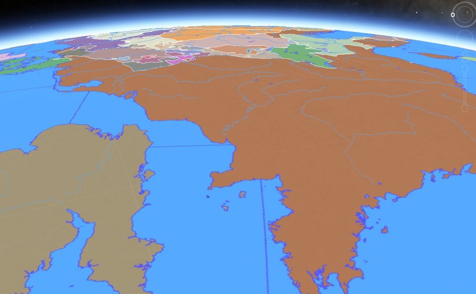
The first shows Napoleonic France in 1812 looking toward the southeast from above the mouth of the English Channel, La Manche. The French Empire at this date is so vast that its furthest limit, the Illyrian Province (largely modern Croatia) sits on the horizon in the distance.

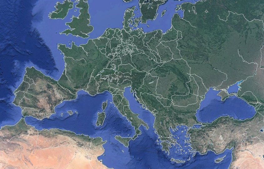
In this view, borders of Europe in 1830 are projected directly onto the standard Google Earth physical earth view.

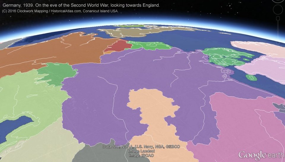
Here we see Europe on the eve of the Second World War projected using CRE data. Germany has annexed Austria and the Sudetenland. We are looking from high above Hungary towards Britain in the distance. The Polish Corridor can be seen extending to the sea in the Baltic. Note that in this view the political entities extend beyond the coastline. This is the natural condition of the political polygons, allowing the researcher to merge the data with any appropriate water/ocean overlay.

Comments:

Falk Kuebler wrote: 2/25/2023
What a stunning piece of both pleasure AND education for all of us, i.e. for Daddy and for my kids 11 and 13. Unfortunately most people don't yet know this marvellous piece of edutainment. I hope this will change quickly.
Sarah B wrote: 2/16/2023
I have been using this program since 1999! I'd LOVE to see an iPad version as I teach 1:1 and have access to airplay. Thanks for keeping this program alive and available after all these years!
Cynthia T wrote: 2/8/2023
How do I download the free version of Centennia Nations Edition? I do not see a link on the website. Thank you!
Frank Reed wrote: 2/8/2023
Sorry for the confusion, Cynthia! Any of the download links here will get you the free version, Centennia Nations Edition. Then later if you buy and enter an access code that will convert into the complete edition of the Centennia Historical Atlas. So there's just the one download ...

HistoricalAtlas.com/download/.
Alex Karalekis wrote: 2/8/2023
I have been using this teaching my Modern European History class with great success. It always draws a little crowd when the map is left in free animation on a big screen!

A. Karalekis
San Diego, California
Ellen M. wrote: 12/8/2022
At last! I'm looking forward to using CENTENNIA Research Edition when my department completes the purchase ..... assuming we can fund it. Can you tell me: are the KML files compatible with Google Earth? Would I be able to show the historical borders of Europe, e.g., in 1499 displayed with the perspective and view features in Google Earth?
Frank Reed wrote: 12/8/2022
Hello Ellen. I have added some sample views showing Centennia KML files viewed in Google Earth.
Jing Chu wrote: 8/14/2022
Hello, Clockwork Mapping. I use the MacOS version of your Cantennia Atlas, and I wonder if you plan to port it to iPad. I think it would be really *slick* on a tablet! Also, do you intend to expand it into the tenth century? My specialty is medieval France, and I would like to see more detail there. Just a wishlist! Thank you for this amazing atlas.
Frank Reed wrote: 8/14/2022
Yes, indeed. We are working on an iPad version. It's mostly a matter of funding. The new "Research Edition" of Centennia will, we hope, provide enough revenue to get the iOS version launched. As for the other item on your wishlist --more in medieval Europe-- it's certainly a possibility in the next year if we can get enough interest. Thanks for letting us know what interests you!

Frank Reed
Owner/Head Cartographer
Clockwork Mapping
Conanicut Island USA
Phil Perry wrote: 6/21/2021
Your historical atlas shows details that I have never encountered anywhere else. I first discovered your maps through a viral video on youtube, and I was appalled to learn later that the video was published without attribution and violating your copyright. I hope you at least got some visitors to your site out of that. It's an astounding accomplishment and obviously a huge amount of research and artistry went into its creation.

Can you email me and let me know if you have any deals for students? I would love to be able to assign this to my students in my European History survey class this summer. Thanks, Phillip Perry, Ottawa.
Frank Reed wrote: 6/22/2021
Hi, Phil. Absolutely -- we do have discount pricing arrangements for students in classes, assuming you would be ordering ten licenses or more. We also have licenses for history departments and small computer labs/libraries. I'll email you.

Frank Reed
Owner/Head Cartographer
Clockwork Mapping
Conanicut Island USA
Janet H. wrote: 11/2/2019
I can't tell you how much I LOVE this atlas. I've been using it for five years in my genealogy research, and there's nothing that compares. If I need to know what was happening in Baden in 1660 or Brittany or Danzig/Gdansk in 1925 or Milan in 1805 or anywhere else at any date... then I can turn to the "Centennia Historical Atlas" for insight. I only wish it covered more centuries, and I'm really looking forward to the version covering the history of North America. Thank you!

J.A.H.
Steve Leonard wrote: 5/18/2022
I’m looking for information. I teach European history and this looks good
Kenneth Rip wrote: 7/3/2022
love Centennia...any chance of adding data for the first millennium?
Shirley Bernadotti wrote: 7/16/2020
More info on the research edition for the MAC. Must have.
Joyce L. wrote: 9/24/2020
Hello, my son purchased one of your maps without me consent and used my card. Is there anyway to get a refund for this purchase?
Samuel Hoskins wrote: 1/10/2021
If I want to use a paper check to pay for Centennia, can I use a discount code with it?
Howard Mayhew wrote: 3/12/2021
Does this atlas has a search for a city? As a Family Researcher, I get names like "Bohemia" or "Pershia"(sp) and the intergal mapping program in Legacy does not report finding these countries.
Will buy latest version for use if it does this search.
Howard Mayhew
htm92941@aol.com (please use, as I have lost much of my hearing).
George H. wrote: 7/22/2021
Wow! I found this through a Youtube video (with attribution!) after searching for something similar (a detailed map of the Holy Roman Empire) and this does not disapoint! While I'm a little shocked at the price tag, even the free version is leaps and bounds ahead of your nearest competitor (Harvard University, who doesn't let non-students access the map for any price AND whos map isnt even as detailed!) I know I will eventually buy the full version as I love this so much already!
Ari in NYC wrote: 7/30/2021
Frank,

Another voice of acclaim for your work. I licensed the application with great delight soon after 2005.

Please add my vote to the requests for an iPad version.

With appreciation and thanks,

Ari M
John Perry wrote: 9/11/2021
I see little mention of genealogy. Without Centennia (Millennia back in the 1990's) I don't know if I would have ever known to look for my northern Germany ancestors in the Scandinavian (Denmark) section of the genealogy library. My grandmother was born in Lublin. I assumed Poland, not Russia at the time. A very useful genealogy tool, thanks.
Brason wrote: 10/1/2021
This is cool, I did not realize how much Europe change in that time period.
Zoltán Györe wrote: 12/28/2021
I use this atlas for about 10 years with great pleasure. It is practical, precise and very useful so I recommend it also to my students of history, culturology and hungarology. Thank you very much!
Ipek Yosmaoglu wrote: 3/10/2020
I have used Centennia in my classes in the past. I still have the software on my computer but it won't open, it says the developer of the app needs to update it for it to work with current version of MacOS. What do you suggest? Do I need to re-purchase the app?
Fernando Julio Korndörfer Neto wrote: 1/7/2023
Two questions

Your Comment or Question:

Please enter the total of all three dice:
BUY NOW

Contact

Contribute

  • We need your support: Please consider contributing to our development work and future mapping projects.

News

  • Centennia: Research Edition ($) extensive GIS versions of Centennia's primary historical database, CRE has been developed for academic research. Institutional licensing fees apply.
  • Centennia: Nations Edition 1789-1939 FREE.
  • German and Greek included.
  • Physical copies now on USB flash (cd-rom available if you must!).
  • Get it here, by download or on USB, or buy on : Amazon.
  • Review by Kevin Kelly, founder/editor of WIRED magazine.
  • Frank Reed, Creator of the Centennia Atlas, guest expert on Neil deGrasse Tyson's StarTalk.
  • Like us on Facebook: FB-logo / HistoricalAtlas.